Journal of the NACAA
ISSN 2158-9429
Volume 12, Issue 1 - June, 2019
Understanding Soil Compaction: A Program for Master Gardeners
- Yergeau, S. , Environmental and Resource Management Agent, Ocean and Atlantic Counties, Rutgers Cooperative Extension
ABSTRACT
An education program on soil compaction was developed and implemented for Master Gardeners in New Jersey. Since 2016, five workshops were presented to 114 Master Gardeners from Ocean County. The workshops involved a mixture of lecture and hands-on use of a soil compaction tester. A pre- and post-test administered during each workshop showed a significant increase in participants’ knowledge, with scores averaging 67.2% before the workshops to 88.7% after the workshops. Testing Master Gardeners’ yards indicated their lawns were not compacted. These data showed this program effectively educated Master Gardeners and incorporated their results into a soil compaction database.
INTRODUCTION
Soil compaction, the hardening of soil due to soil particles compressing closer together, negatively affects many soil properties and functions, whether physical, chemical, or biological in nature (Batey, 2009). Compaction affects soil health in agriculture and horticulture, as it inhibits root growth, hinders water infiltration, and increases stormwater runoff and flooding (Figure 1). With increasing development in New Jersey, severe soil compaction with heavy construction equipment is a common problem as land is developed. Compaction during construction makes establishing and sustaining ground cover with turfgrass and other plantings difficult.
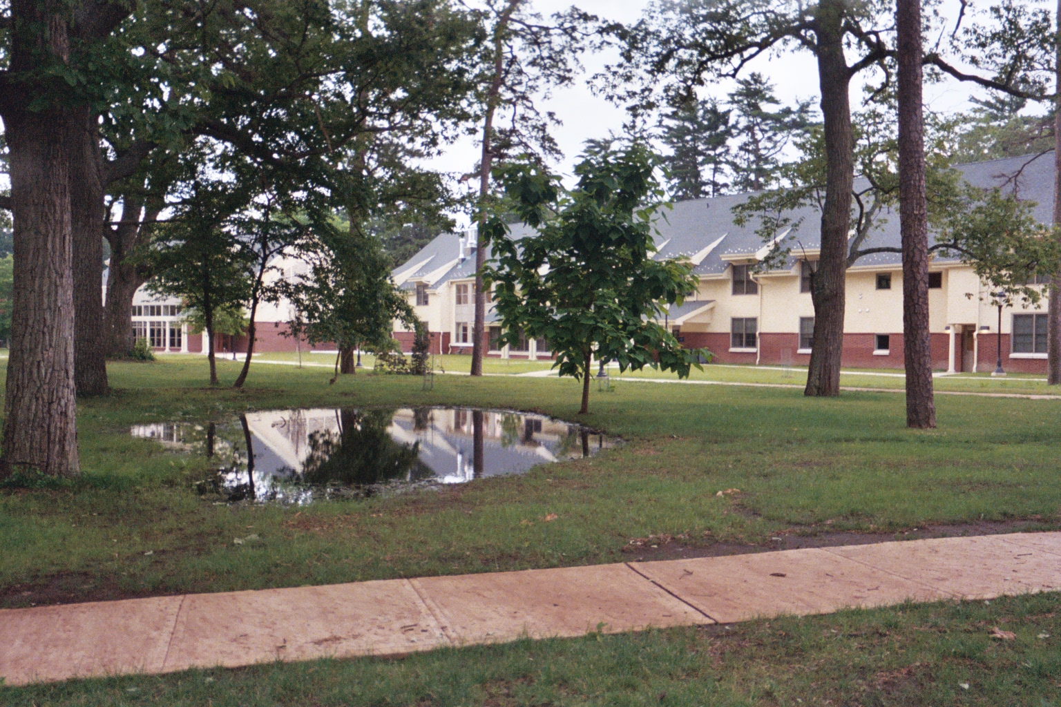
Figure 1. Ponding of water on soil surface due to compaction.
Many management techniques are available to alleviate compaction, such as not using heavy machinery on wet soils, mechanically breaking up compacted soils, replacing topsoil, or planting deep-rooted vegetation prior to the formation of soil compaction. The goal of these management practices is to restore natural function to the soil. Conducting a survey on baseline soil compaction can determine if mitigation is warranted. Rutgers Cooperative Extension in Ocean County implemented a workshop for Master Gardeners to conduct such a survey.
Rutgers Master Gardeners (RMGs) were asked to take measurements to see if soils in Ocean County were compacted. RMGs were chosen because: a) they have a unique set of qualifications to collect this type of data, b) they are Extension volunteers who enjoy the outdoors, c) they possess a strong knowledge of soil health, and d) they are looking to expand their knowledge into other aspects of horticulture.
Since 2016, RMGs in Ocean County participated in workshops that covered soil health, mitigation options, and how to measure soil compaction in the home landscape. During the workshops, RMGs were instructed on how to use a penetrometer that was available for them to borrow to test compaction in their home lawns, and on how to report their findings (Figure 2). The objective was to utilize RMGs to gather a snapshot of soil compaction in coastal New Jersey as a basis for future soil management decisions.
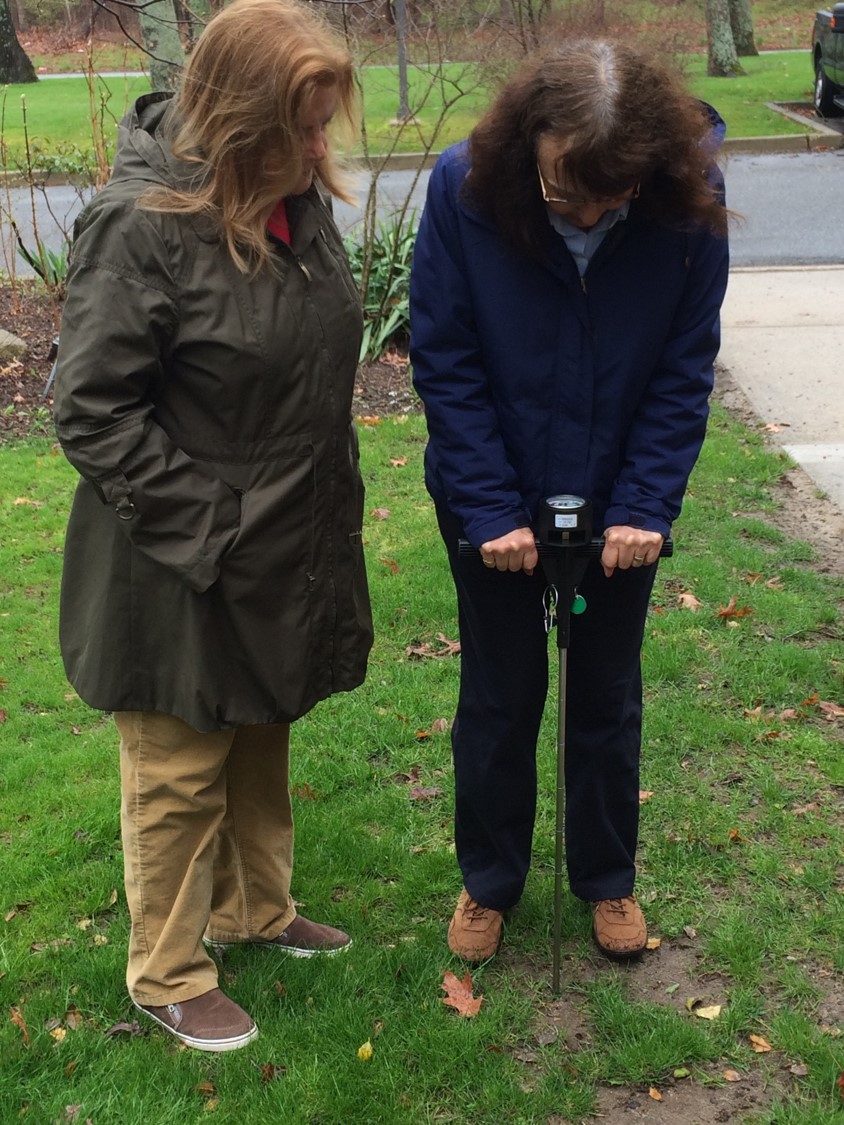
Figure 2. RMG volunteers using a soil compaction tester during the workshop.
METHODS
Workshop Design
The ‘Understanding Soil Compaction’ workshop was designed as a single 2-hour program covering the causes of soil compaction, the impacts of compaction on soil health, compaction management techniques, and how to assess soil compaction in the home landscape.
The program included two parts:
- 1-hour lecture on soil compaction and related topics.
- 1-hour hands-on session where participants learn to use a penetrometer to test soil compaction of turfgrass (Figure 2).
The goals of the workshop were to:
- Educate RMGs on soil compaction and its associated causes, environmental impacts, and remediation.
- Involve RMGs in hands-on, field experiences and data collection (i.e., citizen science).
- Obtain a ‘snapshot’ of the degree of soil compaction in Ocean County.
The following learning objectives guided the design of the ‘Understanding Soil Compaction’ curriculum:
- RMGs will be able to describe what soil compaction is and how it forms.
- RMGs will be able to explain different techniques to mitigate soil compaction.
- RMGs will be able to test for soil compaction using a penetrometer.
Curriculum components developed for the workshop included:
- Scripted slide set entitled “Understanding Soil Compaction.”
- MP3 audio version of the presentation script.
- Detailed step-by-step instruction sheet on how to measure soil compaction using a handheld static cone penetrometer (DICKEY-john Corporation, Springfield, IL, USA).
- 10-question test utilized pre- and post-presentation of the scripted slide set to evaluate change in knowledge.
- 3-page supporting website, “Understanding Soil Compaction” (http://ocean.njaes.rutgers.edu/UnderstandingSoilCompaction.html).
The full curriculum materials are available for download on the Rutgers Cooperative Extension of Ocean County’s website at http://ocean.njaes.rutgers.edu/UnderstandingSoilCompaction.html.
Learning Impact Evaluation
A 10-question true or false style test was administered to workshop participants before each presentation. The same test was given at the end of the workshop to evaluate any increase in knowledge attendees may have experienced due to the intervening workshop. All tests were anonymous.
Data Collection
Soil Compaction Depth
In addition to the workshop presentations, RMGs were asked to volunteer to use a penetrometer/soil compaction tester on their home yards. All RMGs who attended the workshop were trained in the data collection protocol which was similar to the one used by the author in a study on rain gardens (Yergeau and Obropta, 2013).
Soil compaction was measured using a handheld static cone penetrometer (DICKEY-john Corporation, Springfield, IL, USA; Figure 2). Soil compaction was reported as the depth reached when critical compaction occurred. Critical compaction was defined as a soil resistance of 300 pounds per square inch (psi) (Burton and Pitt, 2002). The penetrometer was pushed into various locations within the volunteer RMG’s lawn until the gauge read 300 psi. The distance that the rod penetrated into the soil was measured and recorded: the deeper the depth of the penetrometer, the less compact the soil. Even pressure was applied to the handles on the instrument to keep the rod point penetrating the soil at a slow and constant rate. A minimum of 10 soil compaction measurements were collected from each lawn. The mean depth to soil compaction was calculated from these measurements and used in subsequent data analyses. The standard operating procedure (SOP) used by RMGs for the penetrometer is available for download on the Rutgers Cooperative Extension of Ocean County’s website:
http://ocean.njaes.rutgers.edu/Resource%20Management/RCESoilCompactionSOP2018.pdf.
All RMGs were instructed to only sample turf/grassed areas of their lawns when obtaining soil compaction readings. Lawns and turfed areas were chosen since they are consistent in many yards, whereas other types of landscaping are individualized to each yard, which would make overall comparisons between yards difficult.
Soil Moisture Content
A factor that contributes to the level of compaction measured by the penetrometer is the soil moisture content. Because of this, RMGs were also instructed to take soil compaction depths and soil samples two to three days after a rain event or after lawn irrigation to ensure that moisture levels had moderated in the soil.
In addition to soil compaction measurements, RMGs collected samples for soil moisture content. Plastic zipper lock bags were used by RMGs to collect small samples from their yards and create a composite sample for analysis. Moisture content sample sites did not have to be in the same location as the compaction depth measurements, but did have to come from the same yard areas.
Soil moisture content was analyzed by the Rutgers Soil Testing Laboratory (https://njaes.rutgers.edu/soil-testing-lab/). After the samples were delivered to the soil lab, they were logged and ceramic lab dishes were labeled and weighed. The soil sample was transferred from the plastic bag to ceramic dish and immediately weighed (total weight, i.e. dish and wet sample). Samples were put in a 105°C oven to dry overnight or more before dry weight was measured. The dried samples were returned to the oven for another overnight cycle of drying, and a second dry weight was measured to assure there was no further loss of moisture mass (S. Murphy, personal communication, October 5, 2018). The soil moisture content was calculated as: (dish + moist sample weight)-(dish + oven-dry sample weight)/[(dish + oven-dry sample weight) – (dish tare weight)]. Calculations were multiplied by 100 and expressed as a percentage (% soil moisture). All sample collection procedures and data sheets accompanied the equipment, which was maintained by RCE of Ocean County staff.
Statistical Analysis
Paired sample F-tests and t-tests were used to analyze differences in the pre- and post-tests. A significance level of p < 0.05 for all statistical tests was considered significant. Statistical analyses were conducted using the statistical software package in Microsoft Excel™.
RESULTS
Learning Impacts
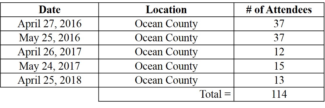
From 2016 through 2018, five workshops were conducted, with a total audience of 114 Rutgers Master Gardeners from Ocean County (Table 1).
Table 1. Date and number of attendees for ‘Understanding Soil Compaction’ workshops covering 2016 – 2018.
The pre- and post-test was administered to the 114 ‘Understanding Soil Compaction’ workshop attendees to gauge the increase in their knowledge on soil compaction, its effects on soil health, and how to assess soil compaction. Correct answers from participants showed a significant increase in scores from an average of 67.2% during the pre-test to an average of 88.7% in the post-test (10 knowledge-based questions; t(192) = 1.65, p < 0.0001, n = 106).
Soil Compaction Depth
The RMGs of Ocean County were trained to use a soil compaction tester (a.k.a., a penetrometer) and how to collect soil samples for soil water content analysis. Of the 114 Rutgers Master Gardeners trained, 69 (60.5% of attendees) signed up from April 2016 through July 2018 to test their home lawns and have reported their results.
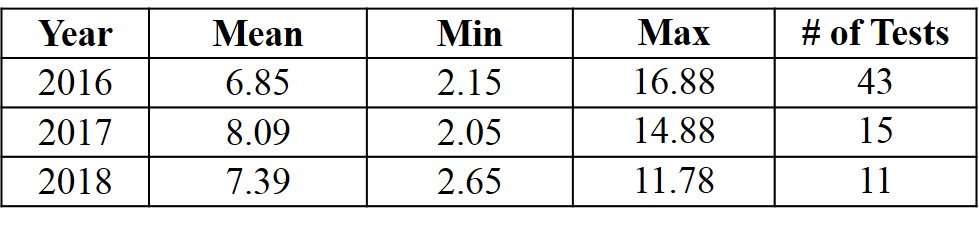
For our monitoring, soil compaction depth is reported as the depth reached when critical compaction occurs. The RMGs’ compaction results averaged 6.85 inches (in.) during 2016, 8.09 in. for 2017, and 7.39 in. for 2018 (Table 2a). The soil compaction depths ranged from a low of 2.05 in. during 2017 to a high of 16.88 in. for 2016 (Table 2a). With these soil compaction depths, the deeper the penetrometer entered the soil the less compacted the soil.
Table 2. Soil compaction depth results in inches (a) and soil moisture content data (b) for Ocean County from 2016 – 2018.
(a)
(b)
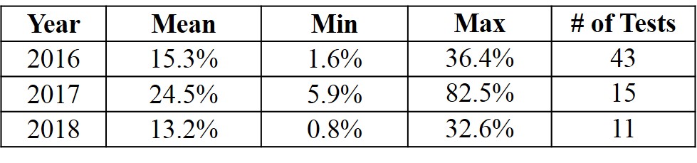
Soil Moisture Content
The soil moisture content results averaged 15.3% in 2016, 24.5% for 2017, and 13.2% for 2018 (Table 2b). Soil moisture ranged from a low of 0.8% in 2018 to a high of 82.5% for 2017 (Table 2b).
DISCUSSION/OUTCOMES
Compaction affects soil health by hindering plant growth, reducing biodiversity in the soil, and preventing groundwater recharge. Educating the public on soil compaction is the first step in minimizing these impacts. To find ways to correct compaction, one first needs to understand the extent of compaction in the home landscape and get basic information on whether or not compaction is occurring. Involving Master Gardeners in this effort was a natural fit for collecting this information, as Master Gardeners already have a knowledge of soil science and the importance of healthy soils to horticulture.
The results from the pre- and post-tests given to workshop attendees showed that the ‘Understanding Soil Compaction’ program was successful in increasing participants’ knowledge on the causes of soil compaction, how to alleviate compaction, and how to test for compaction. This indicates that a structured program incorporating both a lecture and hands-on activity is an effective option when training Master Gardeners.
The soil compaction depth recorded by the RMGs showed that, in general, their yards were not experiencing compaction (Table 2a). For our purposes, a depth less than 3 inches indicated severe compaction (Burton and Pitt, 2002). At least one yard in each of the sampling years (2016-2018) experienced this level of compaction. We worked with those RMGs in Ocean County to develop a strategy for mitigating their compaction.
The curriculum used to train the RMGs of Ocean County was used to train other counties’ programs in southern New Jersey. During spring 2018, workshops were conducted for RMGs of Monmouth, Atlantic, and Cape May Counties and the information gathered will be combined with the Ocean County data to develop a regional snapshot of soil compaction.
Future plans are to adapt these workshops for the general public. The biggest challenge in expanding to the public is the data collection from their yards; for instance, it may not be practical to provide a penetrometer to a large number of homeowners. It is unknown at this time if that will be part of the public programming on soil compaction or if a modified data collection method will be developed and used.
RMGs of Ocean County strive to help the public with their horticulture needs. By providing an educational program that uses traditional teaching with citizen science, we have increased their knowledge of an issue that may affect the home gardener. Master Gardeners have found value in receiving education about plants and horticulture through hands-on activities (Schrock et al., 2000). In addition, the incorporation of scientific data collection and research into the ‘Understanding Soil Compaction’ program has proven to improve the experiences of Master Gardeners (Davenport-Hagen et al., 2018; Meyer et al., 2014). The RMGs in Ocean County have proven invaluable to this monitoring effort, which could not have happened without them.
More information may be found on the Rutgers Cooperative Extension of Ocean County’s web site: http://ocean.njaes.rutgers.edu/UnderstandingSoilCompaction.html.
LITERATURE CITED
Batey, T. (2009). Soil compaction and soil management – A review. Soil Use and Management. 25: 335-345.
Burton, Jr., G.A. and Pitt, R.E. (2002). Ecosystem component characterization. Stormwater Effects Handbook: A Toolbox for Watershed Managers, Scientists, and Engineers. CRC Press, Boca Raton, FL. 345-573.
Davenport-Hagen, L., Weisenhorn, J., and Meyer, M.H. (2018). Applied research engages Extension Master Gardener volunteers. Journal of Extension, 56(4): 4IAW5. Available at: https://joe.org/joe/2018august/iw5.php.
Meyer, N.J., Scott, S., Strauss, A.L., Nippolt, P.L., Oberhauser, K.S., and Blair, R.B. (2014). Citizen science as a REAL environment for authentic scientific inquiry. Journal of Extension, 52(4): 4IAW3. Available at: https://joe.org/joe/2014august/iw3.php.
Schrock, D.S., Meyer, M., Ascher, P., and Snyder, M. (2000). Benefits and values of the Master Gardener Program. Journal of Extension, 38(1): 1RIB2. Available at: https://www.joe.org/joe/2000february/rb2.php.
Yergeau, S. and Obropta, C. (2013). Preliminary field evaluation of soil compaction in rain gardens. Journal of Environmental Engineering. 139(9): 1233-1236.